Tau't Bato Tribe

Tau't Bato Tribe
The Tau’t Batu, Tao't Bato, or Taaw't Bato (translates to "people of the rock" in English) are indigenous people in high-lying areas of Mt. Mantalingajan. Most of them are still using the ancient mode of living, like hunting and farming. They also use caves as their home, but some already have houses made of light and sturdy materials like nipa, coconut leaves, and wood. During our visit, I noticed that most women use clothes to cover their bodies while shirts and G-strings for the men.


Click Helpful Links Below:

San Diego Church, Silay

San Diego Church, Silay
The San Diego Pro-Cathedral, formerly known as San Diego Parish Church or St. Didacus Parish Church, was declared a pro-cathedral in 1994. It is the only church in Silay City that features a dome, which is like St. Peter's in Vatican City. It was established in 1776 using bamboo, cogon grass, and nipa palm. Then it was in 1841 when this parish was constructed using stone and wood, led by Fr. Eusebio Locsin. A grander structure was made in 1925 and replaced the old church. A wealthy sugar baron, Don Jose R. Ledesma from Silay, donated some of the funds for building the new structure. Lucio Bernasconi, an Italian architect, was chosen to design the new structure, wherein he took inspiration from Italy.

Mt. Binacayan - Hike Guide You Need To Know

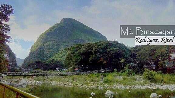
Mt. Binacayan
Mt. Binacayan measures 426+ MASL, and it's a small but tiring hike because of its terrain. Though separated by the Wawa River from Mt. Pamitinan, Binacayan almost has the same features in terms of difficulty and trail types. Some fruit-bearing trees and shrubs bloom like ornaments, and the lullabies from birds can be heard. You will be certified as a "revel in trekking" because of the rock climbing and scrambling on the boulders and limestone cliffs with sharp edges. Below are its specifications:

Mt. Marami - Hike Guide You Need To Know

Mt. Marami
By elevation, Mt. Marami measures 405+ MASL, and it is a mountain in Cavite that can give you relaxation because everything is surrounded by green, while the slopes from afar are picture-perfect. With that in mind, this mountain is getting its own record as one of the hiking destinations in Southern Luzon. Not only that, it is also one of the most visited mountains in the province because of its simple and gradual trails. You can't stop yourself from a death-defying pose on the rock formation called "silyang bato." Fruit-bearing trees, coconuts, bananas, and other crops can give you a Farmville feeling while the birds are singing their lullabies. Below are its specifications:

Mt. Talamitam - Hike Guide You Need To Know

Mt. Talamitam
Though no trees are dancing and birds singing, the nude shape of Mt. Talamitam, with elevation: 630+ MASL, makes it one of the hiking destinations in the Province of Batangas. Considered a friendly mountain for beginners, yet it can bring a remarkable hiking experience to seasoned hikers because of its soil type, which is slippery and muddy during the wet season and hot during summer. As you can see in the photo above, it is covered with green, which brings a relaxing aura to the eyes.

Mt. Pico de Loro - Hike Guide You Need To Know

Mt. Pico de Loro
Mt. Pico de Loro or Mt. Palay-palay, located in Ternate, Cavitehas a combination of beauty and trekking adventure; it has a lot to offer in terms of natural beauty and richness. Birds are singing, colorful flowering plants on the ground, orchids hanging on the branches, bananas, and fruit-bearing trees like coconuts and mangoes. Reaching the top of the Monolith or the Parrot's Beak is a must-have because it will test your fear and agility. Its name was given by the Spanish seafarer because it looks like a parrot’s beak from afar. Refer to the details below for its specifications:

Mt. Damas - Hike Guide You Need To Know

Mt. Damas
Mt. Damas, with an elevation of 685+ MASL, is a mountain in Tarlac with amazing views from its summit, healthy forest areas, and cool weather. Although until now, it is under debate whether it’s a minor or a major hike. Others would say it’s minor because of its elevation, but others would say it's major because of its trail type and technicalities. During our ascent, they were both correct; the entire journey was composed of an uphill and downhill trek with a river crossing. That doesn't end there; since it's wet season, the muddy and slippery terrains made our journey remarkable.

Mt. Daraitan - Hike Guide You Need To Know

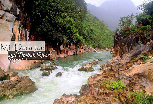
Mt. Daraitan
Mt. Daraitan, with the stunning view of the Tinipak River, is a perfect place to relax and re-energize your body. When we saw the gorgeous photos of this mountain, we thought it had calmness and the positivity that nature possesses. Also, hiking this mountain and crossing the river can give you a unique experience because the place is surrounded by relaxing greens, and the sound of the rushing water by the river preserves tranquility. Aside from this mountain, the province of Rizal has a lot to offer, from arts, crafts, food, rivers, and caves.

Mt. Maculot - Hike Guide You Need To Know

Mt. Maculot
I'll place Mt. Maculot as the second highly recommended mountain to hike in Batangas because of different factors. Can also be one of the best options for day hikes because of its minor trail type and terrains that are covered with trees and surrounded by grass and shrubs, the air is the fresh, cool ambience and a perfect location for a stunning shot with the world famous and most active Taal Volcano on the background. In addition, the Rockies are the best and most famous part of this mountain range.

Mt. Lubog Traverse to Mt. Hapunang Banoi

Mt. Hapunang Banoi
Mt. Hapunang Banoi is situated beside Mt. Pamitinan, and separated by Wawa Dam from Mt. Binacayan. These mountains in Montalban, Rizal are now famous in the mountaineering world because it is surrounded by luscious green trees, making the area look so relaxing, and the wind is cool, clean, and fresh. Plus, the exhilarating terrains added an adventure to hikers; a perfect place to relax and an Instagram-worthy worthy.