
Jump to: | About | How to Get There | Trail Information | Travel Tips | Where to Stay
About Mt. Tarak
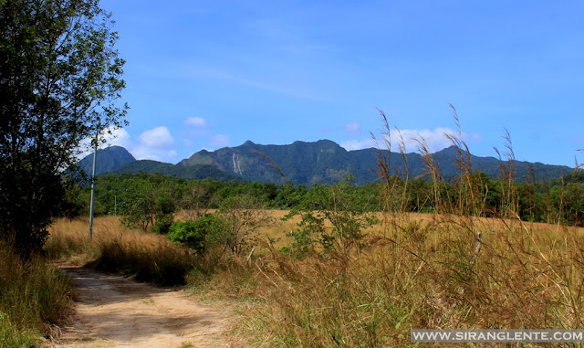
Mt. Tarak — also known as Tarak Ridge—is one of the most iconic mountains in Bataan, offering a mix of forest trails, rocky ascents, stunning ridge views, and the refreshing Papaya River. With an elevation of around 1,130 MASL, this mountain attracts both seasoned hikers and adventurous beginners looking for a thrilling yet rewarding climb. Tarak Ridge is famous for its panoramic views of Manila Bay, Corregidor Island, and the surrounding peaks of the Mariveles Mountain Range.
Mt. Tarak is part of the Mariveles Mountain Range, a collection of volcanic peaks in Bataan that includes Pantingan Peak, Mariveles Ridge, and the towering Mount Mariveles summit. Tarak is particularly well-loved for its windy ridge where hikers pitch tents overlooking breathtaking mountain silhouettes and sea views.

One of the highlights of the climb is Papaya River, a refreshing river stop where trekkers can rest, refill water, and enjoy natural pools before continuing to the ridge. The trail offers a good combination of moderate forest paths and steep rocky assaults, making it a perfect training ground for major climbs.
How to Get to Mt. Tarak
From Manila
- Ride a bus bound for Mariveles (Genesis, Bataan Transit). Travel time: 3–4 hours.
- Ask to be dropped off at Barangay Alas-Asin.
- Walk or ride a tricycle to the Barangay Hall / Registration Area.
- Secure permits and hire a guide if needed.
12Go Transport Option
Looking for a convenient way to reach Bataan? Skip the long lines and secure the best travel deals instantly — book your bus, ferry, and train tickets with 12Go. Book your Manila-to-Bataan bus tickets through: https://12go.tpx.lv/28wx175m — the fastest, hassle-free platform for comparing routes, schedules, and prices in one place.
Trail Information
- Elevation: ~1,130 MASL
- Difficulty: 4/9 (Climb Philippines)
- Trail Class: Minor climb, moderate to challenging
- Hours to Ridge: 4–5 hours
- Hours to Summit: +1.5–2 hours from Ridge
- Water Source: Papaya River (clean and flowing)
Trail Highlights
- Papaya River (cold natural pools)
- Steep rocky assault before the ridge
- Windy ridge perfect for camping
- Views of Manila Bay, Corregidor, and Cavite highlands
- Sea of clouds on lucky days
Mt. Tarak Overnight Hike Guide
Overnight (Recommended)
- Day 1: Trek to Papaya River → Ridge (camp)
- Day 2: Break camp → Descend
The Trails
The first part was walking on the concrete road, passing by the residential houses. Then, an un-cemented road to Nanay Kurding's house, with trees, plants, and grasses on the side. The cold wind still blowing, with an emo soundtrack playing. "Bakit nga ba lahat nalang ang cold. Haaayyyssss" Nanay Kurding and her house are very prominent to hikers; this is where another registration is made.


Reached Nanay Kurding's House
After Nanay Kurding's house is the start of the actual ascent. The trail is ascending; it's clear and orange trail marks hanging are visible. The terrain is composed of stones, boulders, grass, vines, trees, and dust. The trail is covered with hardwood trees and vines that made our hiking experience relaxing while the fresh air blows - just for this part. Another part would be an uphill where the tall brown grasses are on the trail sides. Next is a gradual trail to the Papaya River, which still has forested mountain trails.


Break time at Papaya River
We arrived at the river around 10:30AM. The face of Papaya was totally different during my first hike. Nonetheless, the area still has a relaxing ambiance, surrounded by trees and plants, the cool and fresh air still blowing with the beat of the splashing water in the background. Please note that this river is a common rest area and water source before the assault trail to the ridge and the summit. While the open spaces by the river serve as the campsite for those who prefer unli water.

We stayed by the river for almost an hour and continued ascending; the next part was the hardest. This involves terrain with woodlands, an assault, or steep trails; the photo above will explain. Honestly, it was challenging, with a full-pack backpack on my back, holding a container filled with 3 liters of water, and my Canon DSLR camera in the sling. Akala ko kaya ko mag-isa, pero kailangan ko parin palang dumipende sa mga ugat at sanga ng puno para hindi ma-fall. Ayoko na ulit ma-fall, last time na-na-fall ako, nasaktan ako ng sobra. Sabi nga ng tarsier, kapit lang besh, matatapos din ang hirap na ito.


Camped by the Ridge
At 1:27PM, I finally stepped on the part with open space and has stunning view of Bataan. Rested for twenty minutes while taking photos of the ridge and the emerald seas from afar. The cold wind from the ocean never stops blowing which creates a relaxing sensation. With the magnificent view, I felt lazy and just wanted to take a nap, but it didn't happen since we were aiming for the availability of the mini forest as our campsite.
5PM, started preparing for dinner, then, followed by photo ops with the golden sunset. The temperature was still decreasing and the sound of wind blowing the leaves and branches was like a wave by the shore. DINNER TIME and the most awaited part - The Socials. Remarkable part was playing The Bobo Game. Category: Anything na maitim o madilim sa isang tao. Mga kakatuwang mga sagot: kili-kili, tuhod, buhok, maitin na budhi at syempre mawawala ba ang aking: "Madilim na Kahapon." LIGHTS OFF at 11PM.

The next day is another day! My body clock woke me up at 3AM, and it was really cold. Sound trip for more than an hour while waiting for the others. When I noticed the sunlight penetrating the tent, I went out and prepared something warm. PREPARED BREAKFAST. Photo Ops. Others ascended to the summit and BREAK CAMP at 9AM.


Our Descend
Descending is much easier than ascending but still challenging due to its steepness. Hikers have no choice but to hold on to the roots and branches to avoid injuries. The photo above will describe what I am talking about; this is just one of the exciting parts of our hike. I forgot to mention that during this hike, there were hundreds of trail runners on the trail; of course, they were running. That's why they are trail runners. Since we are walking, we are trail walkers!!!!!?????
Due to unavoidable circumstances (kailangan lang talagang maka-uwi agad), we regrouped; Rachel and Tin proceeded while the others stayed in Papaya River for a snack. This time, we were able to meet more people, the trail runners and hikers from the other groups. Hi, Hellow, Chika Chika onti and proceed walking.


We continued walking, passing Nanay Kurding's house, and the downhill cemented roads. Pinagud na talaga namin ang mga sarili namin. Bawal magpahinga hanggang wala sa highway. Pinagbawalan ko pa yung dalawang sumakay. Hahaha. Kahit ilang beses silang pumara ng trike. But we were almost when 2 guys signed (pointing to the right turn). They look like marshals from the Barangay, so without hesitation, we followed them, turned right and straight ahead. We approached another group (in black) by the highway who helped us crossing the busy highway.
Anlaki ng question marks namin sa aming mga isipan nung mga panahon iyun. Bakit kami pinaliko nang ilang beses, e ilang metro nalang nasa highway na kami. Nasagot iyun sa huling liko namin. Yung pinagdadaanan pala namin was intended for the runners - yun pala yun. Kaya hindi ko napigilan ang sarili ko at nasabi ko kay sir na naka black, na may walkie talkie, na naka-motor ang mga katagang: "Sir, pagsabihan nyo naman yung unang grupo na nagpaliko samin, magtanung kung runners o hikers. Sa laki ba naman ng mga backpacks namin, mukha ba kaming runners?" Sabay walk-out habang may gumigilid na luha sa mga mata ko at nagsasalita si Sir. No. Don't follow me and please don't talk to me. We're done!!! Gusto nyo yun??? Continued walking, passing Barangay Hall of Alas-asin and to the highway. Syempre joke lang yung walk out na part, eksena sa pelikula yung part na yun. Lunch and tidy up at the carinderia by the highway.
Where to Stay
For climbers who want comfort before or after the hike, Bataan has many hotels and resorts near Mariveles. You can easily find discounted rooms through Agoda —perfect for checking real reviews, comparing prices, and booking instantly. Find the best hotel deals and exclusive discounts to save more on every trip: https://agoda.tpx.lv/6qAUQTFd.
Travel Tips
- Start early to avoid the heat and to enjoy ridge views.
- Bring at least 2–3 liters of water; refill at Papaya River.
- Wear gloves—there are rocky sections before the ridge.
- Weather can change quickly; bring rain gear.
- Pitch tents securely—the ridge can get very windy.
- Practice Leave No Trace principles.
Summary
Mt. Tarak is a perfect destination for hikers seeking a scenic yet challenging adventure. From the refreshing Papaya River to the dramatic views atop Tarak Ridge, every step offers something memorable. Whether you choose a day hike or an overnight climb, Mt. Tarak promises a rewarding outdoor experience in the heart of Bataan’s mountains.
As someone who has visited all 82 provinces in the Philippines, I’ve created a complete guide to help you explore each one. Check out my Philippines 82 Provinces Travel Guide here.
No comments:
Post a Comment
Enter Comment Below: